
| 日本語 / русский / Português / Español / 简 体中文 / 繁 體中文 / Español / Français / Nederlands / العربية |
Chapter 1: Dimension two
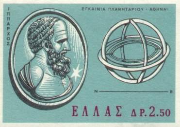
Hipparchus
explains how two numbers can describe the position of a point on a
sphere.
He then explains stereographic projection: how can one draw a picture
of the Earth on a piece of paper?
| To chapter 2 |
1. The narrator |
|
Hipparchus is the first hero of our story, but we must not take what he says too literally! He claims to have been the inventor of both geography and astronomy. This seems a bit exaggerated; who could really lay claim to this? Haven't travelers always described their voyages, and shepherds always gazed at the stars? It is extremely rare that a single individual invents an entire science. Nevertheless, let us pay homage to Hipparchus as one of the greatest sages of antiquity. We know very little about the life of Hipparchus. He was born about 190 B.C. and died about 120 B.C. This article contains a short description and this site a more extensive biography. However, there is no doubt that our sage was one of the very first to produce a catalog of the stars and to measure their positions in the celestial sphere, in fact with astonishing precision. Astronomers have honored Hipparchus by naming one of the craters of the moon after him. Hergé sent Tintin to this crater in Explorers on the Moon, noting that "le cirque d'Hipparque n'a pas besoin de clowns, donc vous ne pouvez pas faire l'affaire..." (For the context of this remark, read Explorers on the Moon!) |
 |
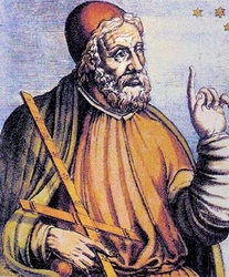 |
The second role in this chapter is played by Ptolemy, who lived three centuries later, between 85 and 135 A.D. Widely recognized as a great astronomer and geographer, he was inspired by the works of Hipparchus, but historians do not agree on the extent of this influence. Did Ptolemy use Hipparchus' measurements instead of making his own? A difficult question, which we will leave to the specialists. For a biography of Ptolemy, click here, and for a more detailed analysis consult this site. And never fear, Ptolemy also has his own crater on the moon! |
2. Longitude and latitudeWhat will Hipparchus and Ptolemy teach us in this first chapter? They will explain the concept known today as a coordinate system. |
|
The Earth is round. We have known this for a very long time, and even before anyone had circumnavigated it clever Greek geometers found a way to measure the circumference quite accurately (see, for example, this page). The Earth makes one revolution each day around an axis which joins two points, called the north and south poles. It also makes one revolution each year around the Sun, but neither Hipparchus nor Ptolemy knew this; instead they believed that the Sun revolved around the Earth. It wasn't until Copernicus, in the sixteenth century, that we began to understand that it is really the Earth that revolves around the Sun. Precisely determining the shape of the Earth took much longer, and in fact it was only a few dozen years ago that we could measure the dimensions to within a centimeter. The Earth is only slightly different from a sphere: it is a little flattened at the poles but the polar radius (6,356 km) and the equatorial radius (6,378 km) are very close. See this page to find out more.
|
 |
|
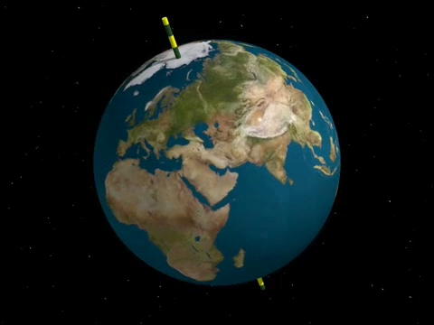
Hipparchus invites us to assume that the Earth is exactly a sphere, and then explains the rudiments of spherical geometry. By definition, a sphere is the set of points in space which are all at equal distance from a single point called its center. A line which goes through the center of a sphere cuts the sphere in two points and gives an axis of symmetry for the sphere. If we choose such a line, we can think of it as the axis of rotation of the Earth, and the two points of intersection are then called the north and south poles. |
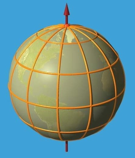 |
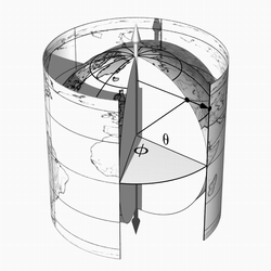
A plane passing through the center of a sphere intersects the sphere in a circle called a great circle, which cuts the sphere into two hemispheres. If the plane passing through the center is perpendicular to the chosen axis, the circle of intersection is called the equator, and the hemispheres are called the southern and northern hemispheres. A plane which contains the axis cuts the sphere in a great circle which goes through the two poles. These circles consist of two semi-circles joining the poles; these are called meridians. Every point on the surface of the Earth, except the poles, is on a unique meridian. Since we are assuming that the Earth is a sphere, all meridians have the same length: this is the distance which one must travel over the surface of the Earth if one wants to go from the North pole to the South pole, i.e. 20,000 km (approximately). Of all meridians on the
Earth, exactly one of them serves as an origin, namely the one which
goes through the observatory of Greenwich in
England; however one could just as well have taken any other for an
origin (and the French would have liked very much for it to have been
the one which goes through Paris!). Any other meridian is described by
an angle (indicated in red on the figure below) which we call its longitude. Geographic
tradition demands that this angle measure between 0 and 180 degrees to
the east or to the west of Greenwich's meridian. |
|
Planes perpendicular to
the axis cut the sphere in circles called parallels.
It is possible
they are called that because they do not intersect each other, like
parallel lines. The parallels become smaller and smaller as they get
closer to the poles. The equator is a special parallel, half-way
between the two poles; it is the longest of the parallels. Each other
parallel is either to the north or south of the equator, and is
described by an angle called the latitude,
indicated in
green on the figure. Every point of the Earth, except the poles, is situated at the intersection of a parallel and a meridian, and we can therefore assign a latitude and a longitude to it. Conversely, if we are given a latitude and a longitude we can locate the point on the Earth... The important thing to remember is that in order to describe a point on the surface of the earth we need two numbers. For that reason we say that the surface of the earth is a two-dimensional object. This reasoning applies not only to the surface of the Earth but also to the plane of a table or the surface of a soccer ball. |
 |
| Click on the image for a film. |
|
Of course we live only approximately on the surface of the Earth! We may find ourselves at times flying in an airplane, for example. The two numbers latitude and longitude are not enough to give our position precisely...we also need to give our altitude, so in fact we need three numbers to describe our point in space. For this reason we say that space has three dimensions, and we will come back to this point later... |
3. ProjectionsIn the second part of this chapter, Hipparchus explains one of the greatest ideas in mathematics, that of a projection. The Earth is round, but we would like to represent it on a plane, such as a piece of paper, in order to make a map which we can put in an atlas. |
 |
There are many methods for drawing a map the Earth. The general principle is to choose a region of the Earth and to associate to each point p of this region a point F(p) on the plane. We have then represented the region in question on a piece of the plane. Choosing the representation F is the essence of the art of cartography; different choices emphasize different characteristics of the region. The ideal would be an isometric map, in which one could measure the distance between two points p and q by measuring the distance between their representations F(p) and F(p). Unfortunately there is no such ideal map, and we must compromise in some way or another. For example, some maps try to preserve areas. Cartography is a fascinating subject with a long history often parallel to that of mathematics, and which has recently made considerable progress thanks to very precise modern measurements and to the help of computers. Here are two sites which can serve as points of entry to the study of this science. |
|
The map which Hipparchus presents to us bears an erudite name: stereographic projection. We should say that stereographic projection is not much used in maps today, except to represent polar zones. But we will see little by little in the course of this film that this projection has considerable mathematical interest and that it is in fact extremely useful. |
|
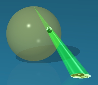
The definition is very simple. We consider a plane P tangent to the Earth at the south pole. For every point p of the sphere which is different from the north pole, we draw the line pn which joins p to the north pole. This line hits the tangent plane P in another point, F(p). Stereographic projection is thus a representation of the sphere (with the north pole removed) in the plane P. Who invented this projection? This is another contentious historical debate...Some think it was Hipparchus, others Ptolemy, and others claim that Hipparchus did indeed invent stereographic projection but did not understand its properties.
|
 |
|
Stereographic projection has three essential properties, closely related to one another. The first property, nicely illustrated in the film, is that the projection transforms a circle on the sphere into a circle or a line in the plane. If you have the patience to wait until the final chapter, you will understand why. |
 |
In order to demonstrate this, Hipparchus rolls the Earth on the tangent plane at the south pole. As a result, it is no longer the south pole that touches the plane, and the projection is no longer from the north pole, but rather from the "highest point" onto the tangent plane at the "lowest point." It may not be realistic to think of rolling the Earth in this way, but it gives very nice projections! Click on the image at left for a film. The second property of stereographic projection, which is not illustrated in the film, is that it respects angles. This means that if we take two curves on the sphere which intersect at a certain angle at some point, then the projections of the curves intersect in the same angle. In the image at left you can see that the projections of the meridians and parallels intersect at right angles, just as they do on the sphere. This feature is useful for a navigator who is charting his course...he would like very much for the angles he is measuring with his instruments to be exactly the same as those on his map. |
|
The third property of stereographic projection is that, even though it does not realize the ideal of preserving distances, it "does the best it can." Take a point p on the sphere and consider a very small region R surrounding p. Stereographic projection sends the region R to a region F(R) around the point F(p). The smaller R is, the better F preserves the form of R. What this means mathematically is that there is a constant k, which we might call the scale of the map in R, such that if q1 and q2 are two points of R, then the ratio between the distances from q1 and q2 (in the sphere) and F(q1) and F(q2) (on the plane) is almost equal to k. What does "almost" mean here? It means that this ratio becomes closer and close to k as R becomes smaller and smaller. In less precise language this means that the map respects the form of very small regions, and for that reason it is called conformal. This is the principal feature of stereographic projection: it is almost perfect for a user who employs it only in a small neighborhood of himself! |
 |
|
After this first excursion, let us re-emphasize the lesson of Hipparchus: the sphere is two-dimensional because we can describe its points by two numbers: latitude and longitude. Furthermore, it is very useful to represent the sphere in a plane using stereographic projection... These lessons will come in very handy for exploring the third dimension...and then the fourth! |
| To chapter 2 |